A Unique History
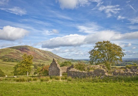
 Most phases in Scottish history are represented in the Campsies. The Gargunnock Hills, Fintry Hills, Kilsyth Hills and Campsie Fells were formed by volcanic intrusion over existing mudstone and limestone beds. These beds can be seen in the bottom of the burn at Campsie Glen, where they are known as the Ballagan Beds, where one of the basalt lava flows can be observed to good effect at a quarry a short distance uphill, on the other side of the Crow Road. Relatively recently people came to live in the river valleys of the Forth, Endrick, Carron, Glazert and Kelvin. There are many prehistoric sites in the area, including Neolithic chambered cairns at Baldernock and an Iron Age Fort at Meikle Reive, above Lennoxtown. There are numerous medieval castles including the impressive examples at Mugdock, Bardowie and Culcreuch (Fintry). Most phases in Scottish history are represented in the Campsies. The Gargunnock Hills, Fintry Hills, Kilsyth Hills and Campsie Fells were formed by volcanic intrusion over existing mudstone and limestone beds. These beds can be seen in the bottom of the burn at Campsie Glen, where they are known as the Ballagan Beds, where one of the basalt lava flows can be observed to good effect at a quarry a short distance uphill, on the other side of the Crow Road. Relatively recently people came to live in the river valleys of the Forth, Endrick, Carron, Glazert and Kelvin. There are many prehistoric sites in the area, including Neolithic chambered cairns at Baldernock and an Iron Age Fort at Meikle Reive, above Lennoxtown. There are numerous medieval castles including the impressive examples at Mugdock, Bardowie and Culcreuch (Fintry).
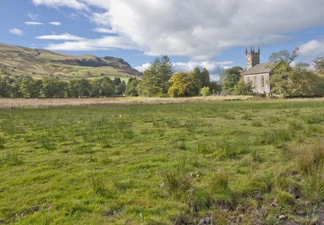
The modern development of the Scottish countryside can be traced by means of evidence in the Campsie landscape. Before the agricultural revolution small tenant farmers lived in fermtouns or clachans – groups of dwellings occupied by individual peasants and their families. These were not villages as we know them, although if the parish church was situated there the fermtoun was known as a kirktoun. Examples of kirktouns survive at Balfron (located by the Clachan Oak, to the north of the modern village), Fintry (to the east of the village) and at Campsie Glen, also known as Clachan of Campsie. Proper villages, with houses for tradesmen/craftsmen, such as shoemakers, tailors, blacksmiths and bakers, and regular fairs and/or markets, began to develop in the late seventeenth century. There are early examples at Buchlyvie (1670s) and Gargunnock (1721).
 Landowners often recognised the value of siting modern industries in these newly-created villages. At first such industries were water powered, and so were suitable for location in the Campsie area, with its numerous rivers and burns, as well as resources of limestone,cementstone and alum. For this reason cotton mills were set up at Balfron (1789-90) and Fintry (about 1792). Around the same time calico printing works, for the block printing of cotton cloth, were established at Balfron, Strathblane, Lennoxtown and Milton of Campsie. The surviving evidence for these industries is limited, although cotton spinners’ houses survive at Fintry. Landowners often recognised the value of siting modern industries in these newly-created villages. At first such industries were water powered, and so were suitable for location in the Campsie area, with its numerous rivers and burns, as well as resources of limestone,cementstone and alum. For this reason cotton mills were set up at Balfron (1789-90) and Fintry (about 1792). Around the same time calico printing works, for the block printing of cotton cloth, were established at Balfron, Strathblane, Lennoxtown and Milton of Campsie. The surviving evidence for these industries is limited, although cotton spinners’ houses survive at Fintry.
To service these industries it was necessary to build new roads, including the Crow Road (built during the 1790s) and the turnpike road between Fintry and Balfron. The latter followed the line of an old drove road which enabled cattle to be moved from Loch Lomond-side to Falkirk Tryst (market), by way of the Endrick and Carron valleys.
Back to top
Geological and Geomorphological Sites
There are a number of Regionally Important Geological and Geomorphological Sites (RIGS) with the Campsies for more information click here
On Everyone’s Doorstep
 A unique aspect of the gloriously scenic Campsie area is its accessibility from the modern population centres of Scotland. A unique aspect of the gloriously scenic Campsie area is its accessibility from the modern population centres of Scotland.
It’s around a short 10-mile journey from Glasgow, Falkirk or Stirling that takes the visitor right into the heart of the Campsies. Glasgow, Falkirk and Stirling, in turn, are readily accessible by road and rail from most towns in the central belt of Scotland, from the City of Edinburgh and further afield.
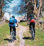
Access to the Campsie Fells can be gained by a variety of routes, for example, the Strathkelvin Railway Path from Kirkintilloch, the Tak Ma Doon Road from Kilsyth, the Carron Valley from Stirling and Denny, or by the West Highland Way from Milngavie.
If starting out by car you can park at the Crow Road car park above Campsie Glen which provides access to the many hill walking opportunities leading off from this road. Alternatively, visitors can take the bus from Glasgow to Campsie Glen and climb the short distance from there onto the Crow Road. Likewise there are other access routes from Fintry, the Carron Valley; Killearn, Balfron and Buchlyvie to the north of the Campsie Fells.
Back to top
Get Up and Go
 With the exception of Fintry, all the main points of access to the Campsies are well served by bus. Campsie Glen from Glasgow Buchanan Bus Station, via Kirkintilloch, Milton of Campsie and Lennoxtown. Balfron from the same Glasgow bus station, via Milngavie, Strathblane, Blanefield, Dumgoyne and Killearn. Balfron also has a regular service from Stirling, with alternative routes via Gargunnock/Kippen/Buchlyvie and Thornhill/Port of Menteith/Aberfoyle. Stirling bus station is situated close to the railway station for easy transfer between train and bus. It should be remembered that the Campsie area bus services are in general less frequent on Sundays. With the exception of Fintry, all the main points of access to the Campsies are well served by bus. Campsie Glen from Glasgow Buchanan Bus Station, via Kirkintilloch, Milton of Campsie and Lennoxtown. Balfron from the same Glasgow bus station, via Milngavie, Strathblane, Blanefield, Dumgoyne and Killearn. Balfron also has a regular service from Stirling, with alternative routes via Gargunnock/Kippen/Buchlyvie and Thornhill/Port of Menteith/Aberfoyle. Stirling bus station is situated close to the railway station for easy transfer between train and bus. It should be remembered that the Campsie area bus services are in general less frequent on Sundays.
Back to top
Round About the Campsies
 The Campsies lie just north of the narrowest neck of land across Great Britain and are flanked by the valleys of the Rivers Kelvin and Carron. Over the centuries strategic barriers and transport routes were created, including the Roman Antonine Wall and the Forth & Clyde Canal. The importance of both has been recognised in recent years with the elevation of the former to UNESCO World Heritage Site status and the re-opening of the latter as the Millennium Link that allows boats to navigate from Bowling on the west coast to Grangemouth and Edinburgh in the east. The Campsies lie just north of the narrowest neck of land across Great Britain and are flanked by the valleys of the Rivers Kelvin and Carron. Over the centuries strategic barriers and transport routes were created, including the Roman Antonine Wall and the Forth & Clyde Canal. The importance of both has been recognised in recent years with the elevation of the former to UNESCO World Heritage Site status and the re-opening of the latter as the Millennium Link that allows boats to navigate from Bowling on the west coast to Grangemouth and Edinburgh in the east.
Interesting Roman sites can be visited at Bar Hill, Twechar (near Kirkintilloch) and Bearsden, where there is an impressive second century bath house. New Marinas have been established on the Forth & Clyde Canal at Auchinstarry, near Kilsyth, Kirkintilloch and at The Falkirk Wheel.
 Proximity to the historic heart of Scotland is underlined by the closeness of Stirling Castle and the Bannockburn battlefield site, to the east. Both enjoy a high standing among Scotland’s premier tourist attractions, as does the Falkirk Wheel on the Forth & Clyde Canal. To the north the Campsies are bounded by the mountains and lochs of the Trossachs and to the west by the world famous Loch Lomond an area now designated as a National Park. Proximity to the historic heart of Scotland is underlined by the closeness of Stirling Castle and the Bannockburn battlefield site, to the east. Both enjoy a high standing among Scotland’s premier tourist attractions, as does the Falkirk Wheel on the Forth & Clyde Canal. To the north the Campsies are bounded by the mountains and lochs of the Trossachs and to the west by the world famous Loch Lomond an area now designated as a National Park.
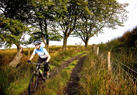
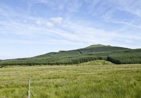
For mountain biking enthusiasts the Carron Valley offers ‘big country’ biking with over 10km of trails, ranging from short routes to more challenging single track and forest roads.
Back to top
Scotland in Microcosm
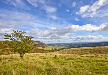
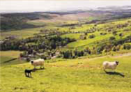
 Visitors to Scotland can expect to find a mountainous landscape studded with mediaeval castles together with stories of highland clans and clansmen, like Rob Roy and the MacGregors, and of the distilling of whisky in remote highland glens. All of this can be found in the Campsies, where high hills can be accessed at Earl’s Seat, Dumgoyne and the Meikle Bin and picturesque castles viewed at Culcreuch, Bardowie and Mugdock. Stories abound of illicit stills in Campsie glens, ‘smuggling’ by local people under the noses of excise officers, and raids ‘down from the hills’ by the MacGregors and other clansmen on the foothill cattle farms. Visitors to Scotland can expect to find a mountainous landscape studded with mediaeval castles together with stories of highland clans and clansmen, like Rob Roy and the MacGregors, and of the distilling of whisky in remote highland glens. All of this can be found in the Campsies, where high hills can be accessed at Earl’s Seat, Dumgoyne and the Meikle Bin and picturesque castles viewed at Culcreuch, Bardowie and Mugdock. Stories abound of illicit stills in Campsie glens, ‘smuggling’ by local people under the noses of excise officers, and raids ‘down from the hills’ by the MacGregors and other clansmen on the foothill cattle farms.
In contrast, the peaceful atmosphere of lowland villages can also be enjoyed. It can be appreciated how these developed out of ancient ‘fermtouns’ in early modern times, and how the ready supply of running water power from the hills led to the establishment of village factories during the early phases of the industrial revolution. At the time, too, the scenic Campsie Glen was opened up by a local landowner for the enjoyment of rural workers. This action, carried out as a matter of principle, was an intrinsic part of the development of modern democratic ideals of the Campsie area.
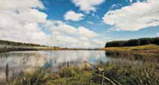
The natural history of the Campsies can provide inspiration for a whole range of separate interests and studies. The higher hills, for example, are noted for their abundance of birds of prey, including buzzards, kestrels and peregrine falcons. Local moors, such as Flanders Moss, enjoy a unique character, with acres of bog cotton springing from the carpet of delicately coloured sphagnum moss, over a foundation of peat.
Back to top
Main Points of Access
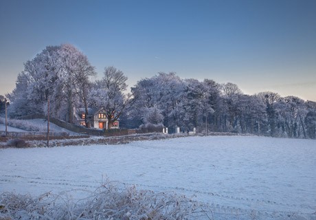
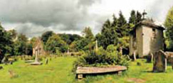
 A pleasant journey from Buchanan Bus Station or a scenic drive from around Glasgow takes you to Campsie Glen, long famous as a mecca for hill walking visitors. This was because, over two hundred years ago, John McFarlan, the laird of nearby Ballencleroch, opened his side of the glen to visitors. He was especially keen to provide this amenity for ordinary working people. His memorial can be seen in the graveyard at the entrance to the Glen. Nearby is the Aldessan Gallery, a building that once housed the famous Crown Inn, opened for the convenience of Glen visitors in 1818, and later the equally famous Red Tub Tea Rooms. McFarlan’s former home, Ballencleroch House now forms part of the site of the Schoenstatt Centre, which includes the Sheonstatt Shrine, an attractive modern chapel, conference facilities and accommodation. A pleasant journey from Buchanan Bus Station or a scenic drive from around Glasgow takes you to Campsie Glen, long famous as a mecca for hill walking visitors. This was because, over two hundred years ago, John McFarlan, the laird of nearby Ballencleroch, opened his side of the glen to visitors. He was especially keen to provide this amenity for ordinary working people. His memorial can be seen in the graveyard at the entrance to the Glen. Nearby is the Aldessan Gallery, a building that once housed the famous Crown Inn, opened for the convenience of Glen visitors in 1818, and later the equally famous Red Tub Tea Rooms. McFarlan’s former home, Ballencleroch House now forms part of the site of the Schoenstatt Centre, which includes the Sheonstatt Shrine, an attractive modern chapel, conference facilities and accommodation.
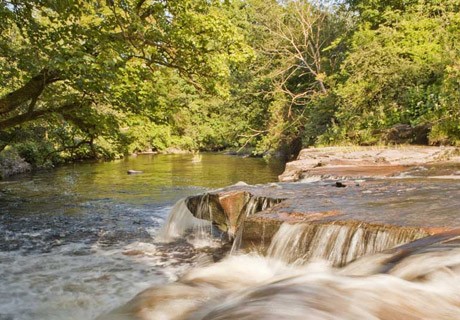
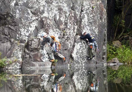
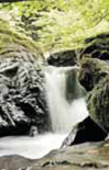
From the bus terminus visitors can gain immediate access to the scenic Campsie Glen, where the burn has cut down through the lava and is now flowing over underlying cementstones, or they can climb up a steep grassy slope to the Crow Road Car Park a short distance away. The Crow Road over the Campsies is an excellent means of access to hilltops such as Cort-ma Law, Holehead, Lecket Hill and the Meikle Bin. Continuing on to Fintry provides access to the Carron Valley and surrounding hills.
 Another option is to take the train from Glasgow (Central or Queen Street Station) to Milngavie and from there proceed on foot along the West Highland Way. This route gives ready access to the historic reservoirs at Mugdock, which provided the City of Glasgow with its first large-scale water supply, and to Mugdock Country Park, including the historic Mugdock Castle. From nearby Blanefield there is a walking route on to the tops of the Campsies, including the summits of Dumgoyne, a volcanic plug and Earl’s Seat. Close to the West Highland Way in this area, is Glengoyne Distillery which provides full visitor facilities throughout the year, including distillery tours and whisky tasting. Another option is to take the train from Glasgow (Central or Queen Street Station) to Milngavie and from there proceed on foot along the West Highland Way. This route gives ready access to the historic reservoirs at Mugdock, which provided the City of Glasgow with its first large-scale water supply, and to Mugdock Country Park, including the historic Mugdock Castle. From nearby Blanefield there is a walking route on to the tops of the Campsies, including the summits of Dumgoyne, a volcanic plug and Earl’s Seat. Close to the West Highland Way in this area, is Glengoyne Distillery which provides full visitor facilities throughout the year, including distillery tours and whisky tasting.
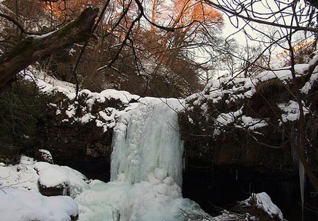
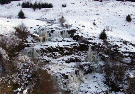
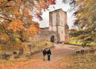
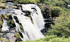
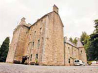
Fintry is the best centre for exploring the Campsies on foot. It is also one of the most attractive villages in the area. The only way of reaching Fintry is by car or bike, as there are no bus or rail services. Keen walkers often reach the area by means of the 5-mile hike from Campsie Glen or through the Carron Valley. From Fintry visitors can explore the Kilsyth Hills, the Campsie Fells, and the Fintry Hills, discover the delights of the Carron Valley Reservoir and Forest and visit the famous waterfall know as the Loup of Fintry. For those with an interest in history, Culcreuch Castle is an excellent example of a mediaeval Scottish tower house. Close to the Carron Valley are the remains of the castle of Sir John de Graeme, one of William Wallace’s generals. Nearby the Clanranald Trust is constructing a full scale replica fort at DunCarron which will depict typical life in medieval times.
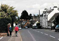
 Balfron is a good centre for getting around the Campsies by bus, with regular services to Buchlyvie, Kippen, Gargunnock, Killearn, Dumgoyne and Blanefield. For those wishing to explore beyond the immediate Campsie area there are services to Drymen, Aberfoyle, Port of Menteith and Thornhill. Nearby Killearn is a centre of historic interest, with a large monument in memory of George Buchanan, a literary genius who lived at the time of Mary Queen of Scots, and also an interesting toll-house, serving as a reminder of the time when fees had to be paid just to pass along the common roads. Balfron is a good centre for getting around the Campsies by bus, with regular services to Buchlyvie, Kippen, Gargunnock, Killearn, Dumgoyne and Blanefield. For those wishing to explore beyond the immediate Campsie area there are services to Drymen, Aberfoyle, Port of Menteith and Thornhill. Nearby Killearn is a centre of historic interest, with a large monument in memory of George Buchanan, a literary genius who lived at the time of Mary Queen of Scots, and also an interesting toll-house, serving as a reminder of the time when fees had to be paid just to pass along the common roads.
Back to top
The Great Campsie Highway
 The B822 northwards from Lennoxtown to Callander can be considered as a definitive spine of access for visitors by car. The route goes straight onto the Crow Road at Lennoxtown, with an immediate opportunity to park above Campsie Glen for access to the numerous hill walking routes in this area. Onwards from here the road goes past Jamie Wright’s Well before descending into Fintry by the Gonachan incline, from where there are excellent views of highland hills to the north. The B822 northwards from Lennoxtown to Callander can be considered as a definitive spine of access for visitors by car. The route goes straight onto the Crow Road at Lennoxtown, with an immediate opportunity to park above Campsie Glen for access to the numerous hill walking routes in this area. Onwards from here the road goes past Jamie Wright’s Well before descending into Fintry by the Gonachan incline, from where there are excellent views of highland hills to the north.
At Fintry there is the option of branching eastwards to the Loup of Fintry, Carron Valley Reservoir and Carron Bridge, or westwards to Balfron and Killearn. Northwards again by the B822 the route passes Culcreuch Castle, on the right, before traversing Kippen Muir, where further fine views of northern mountains can be glimpsed on the way to the village of Kippen. Here the visitor can branch eastwards to Gargunnock or westwards to Arnprior and Buchlyvie.
From Kippen the B822 route goes on past the National Nature Reserve at Flanders Moss, then through the early planned village of Thornhill before arriving at Callander, the gateway to the Trossachs.
Back to top
Heritage Path
The project recently ended its first three year project to identify historic paths, research and promote them and this website is the principal fruit of that project. Visit website | Tel: 0131 558 7123
Back to top |